
 المجالات العسكرية
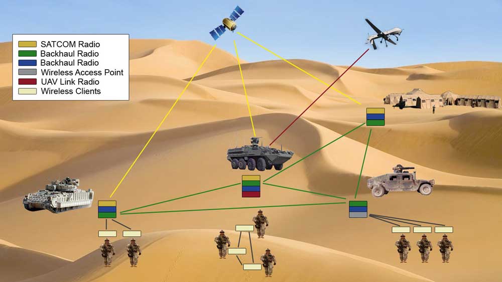
تستخدم نظم المعلومات الجغرافية في المؤسسات العسكرية والامنية اذ تستخدم كثير من البرامج لإعداد الخطط العسكرية والامنية والخرائط وتحديد الاهداف الثابتة والمتحركة. في مجال الاستخبارات الحديثة يتم دمج المعلومات المكانية والمعلومات الجغرافية والمعلومات المساحية والمعلومات الاستخباراتية وجمع العوامل المشتركة بينهم والوصل لنتائج جديدة تمنح للعسكريين معلومات دقيقه عن مواقع الاهداف. ان الطائرات بدون طيار احدى ادوات نظم المعلومات الجغرافية والاستشعار عن بعد المستحدثة.
التنبؤ بالكوارث الطبيعية وحجمها ونطاقها الجغرافي وبيانات المتعرضين لها كالسيول والزلازل والفيضانات وإيجاد الحلول الاقتصادية والعملية واتخاذ الإجراءات الأمنية لمواجهتها وإظهار التوزيع الجغرافي للحوادث بكافة أنواعها كالحرائق والجرائم وحوادث السير.
- تحديد مواقع الاهداف بدقة بواسطة صور الاقمار الاصطناعية وصور الرادار عالية الحساسية التي يتم معالجتها وتحديد نقط جي بي اس على إحداثيات جميع النقط على الخريطة المعنية .
- تحقيق معطيات وصفية فضائية للأغراض المطلوبة.
- نظم المعلومات الجغرافية في قطاعات الدفاع والاستخبارات وتطبيقات الحلول الدفاعية والعسكرية.
- حصر قواعد البيانات الجيومكانية الموجودة حاليا و معرفة اهداف كل منها.
- انشاء نظام ترميز مكانى موحد Geocode لمعالم الطبقات الجغرافية الامنية.
خدمات النظم المعلوماتية في المجال العسكري:
قيمنا
الاحترام والنزاهة الإبداع والابتكار العمل الجماعي والثقة الاحتراف>>
الرؤية
إن رؤيتنا تنعكس بعملنا الدائم لتحقيق مكانة مرموقة في مقدمة المكاتب المتخصصة في مشاريع نظم المعلومات الجيومكانية والاستشعار عن بعد>>
الرسالة
نسعى لخلق علاقة ناجحة ومستدامة مع عملائنا من خلال تقديم التوقعات >>
